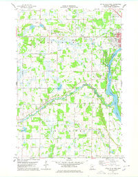
1978 Map of Little Falls West
USGS Topo · Published 1978About this map
Little Falls serves as the primary urban center in this 1970s landscape, positioned along the banks of the Mississippi River. The map illustrates a region defined by its connection to the water and early transportation routes, featuring the Charles A Lindbergh State Park and the expansive Zebulon Pike Lake. The settlement of Sobieski anchors the western portion of the quadrangle, while the local infrastructure is highlighted by the Burlington Northern railroad and an Old Railroad Grade that speaks to the area's evolving transport network.
Find a feature on this map
24 named features on this map. Tap any name to fly to it.
Don’t see what you’re looking for? This feature index may not catch every label — zoom into the map to look around manually.
Map Details
Editions of this 1978 Little Falls West Map
2 editions found
Other maps of this area

1947 · Flensburg
USGS Topo · 1:25,000

1948 · Belle Prairie
USGS Topo · 1:62,500

1948 · Cushing
USGS Topo · 1:62,500

1948 · Little Falls
USGS Topo · 1:62,500

1950 · Swanville
USGS Topo · 1:62,500

1950 · Belle Prairie
USGS Topo · 1:62,500

1950 · Little Falls
USGS Topo · 1:62,500

1950 · Cushing
USGS Topo · 1:62,500

1951 · Flensburg
USGS Topo · 1:25,000

1953 · Brainerd
USGS Topo · 1:250,000