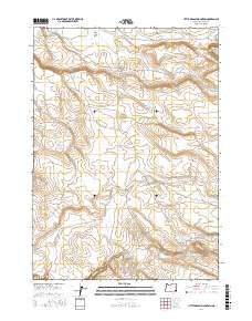
2017 Map of Little Grassy Mountain
USGS Topo · Published 2017About this map
Little Grassy Mtn and the nearby Black Butte anchor this high desert landscape, which is defined by a sophisticated network of water management features. Numerous catchments such as Antelope Reservoir, Little Grassy Reservoir, and the W-Black Butte Reservoir are distributed across the terrain to capture seasonal runoff from drainages like Spring Cr and Jack Cr. The presence of these reservoirs alongside labels such as Rock Creek Flat and Antelope Flat suggests a landscape utilized for livestock grazing where water security is paramount.
Find a feature on this map
32 named features on this map. Tap any name to fly to it.
Don’t see what you’re looking for? This feature index may not catch every label — zoom into the map to look around manually.
Map Details
Editions of this 2017 Little Grassy Mountain Map
This is the sole edition of this map. No revisions or reprints were ever made.
Other maps of this area

1955 · Jordan Valley
USGS Topo · 1:250,000

1957 · Jordan Valley
USGS Topo · 1:250,000

1958 · Jordan Valley
USGS Topo · 1:250,000
1969 · Little Grassy Mountain
USGS Topo · 1:24,000
1969 · Juniper Ridge
USGS Topo · 1:24,000
1969 · Antelope Reservoir
USGS Topo · 1:24,000
1969 · Threemile Hill
USGS Topo · 1:24,000
1969 · Dry Creek Rim
USGS Topo · 1:24,000
1969 · Danner
USGS Topo · 1:24,000
1980 · Skull Creek
USGS Topo · 1:24,000