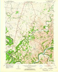
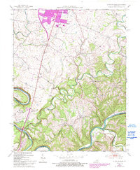
1952 Map of Little Hickman
USGS Topo · Published 1966About this map
The Kentucky River carves a deep, serpentine path through the southern landscape of this 1952 survey, forming the natural border between Jessamine, Garrard, and Madison counties. This river corridor is rich with historical sites, most notably Camp Nelson and the adjacent Camp Nelson National Cem, which dominate the bluff overlooking the water. The upland terrain is defined by a dense network of country roads connecting agricultural settlements like Little Hickman, Vineyard, and Hanly. Smaller community landmarks are frequent, including Roberts Chapel, Crisman Mill, and the Jessamine Childrens Home. The drainage of Hickman Creek and its many forks, such as Elm Fork, creates a dissected topography that historically influenced the placement of early schools and churches like Sulphur Well Sch and Bethany Ch.
Find a feature on this map
42 named features on this map. Tap any name to fly to it.
Don’t see what you’re looking for? This feature index may not catch every label — zoom into the map to look around manually.
Map Details
Editions of this 1952 Little Hickman Map
6 editions found
Other maps of this area

1892 · Richmond
USGS Topo · 1:125,000

1897 · Richmond
USGS Topo · 1:125,000

1905 · Harrodsburg
USGS Topo · 1:125,000

1950 · Bryantsville
USGS Topo · 1:24,000

1952 · Keene
USGS Topo · 1:24,000

1952 · Valley View
USGS Topo · 1:24,000

1952 · Little Hickman
USGS Topo · 1:24,000

1952 · Nicholasville
USGS Topo · 1:24,000

1952 · Buckeye
USGS Topo · 1:24,000

1952 · Coletown
USGS Topo · 1:24,000