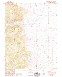
1986 Map of Little Horse Canyon
USGS Topo · Published 1994About this map
The eastern front of the Snake Range dominates this mid-1980s landscape, where the high peaks of the Humboldt National Forest drop sharply toward the Great Basin floor. This rugged interface between mountain and desert is defined by the drainage of Smith Creek and Little Horse Canyon, where a solitary Aqueduct and scattered spring-fed water sources indicate the critical value of water in this arid environment.
Find a feature on this map
18 named features on this map. Tap any name to fly to it.
Don’t see what you’re looking for? This feature index may not catch every label — zoom into the map to look around manually.
Map Details
Editions of this 1986 Little Horse Canyon Map
2 editions found
Other maps of this area

1908 · Fish Springs
USGS Topo · 1:250,000

1910 · Fish Springs
USGS Topo · 1:250,000

1953 · Delta
USGS Topo · 1:250,000

1956 · Ely
USGS Topo · 1:250,000

1958 · Delta
USGS Topo · 1:250,000

1959 · Ely
USGS Topo · 1:250,000

1960 · Conger Range
USGS Topo · 1:62,500

1960 · Gandy
USGS Topo · 1:62,500

1962 · Delta
USGS Topo · 1:250,000

1963 · Ely
USGS Topo · 1:250,000