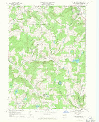
1967 Map of Little Meadows
USGS Topo · Published 1971About this map
The rolling hills of Susquehanna and Bradford Counties are captured in this mid-century survey, showcasing a landscape defined by small rural hubs and agricultural drainage. Little Meadows sits at the northern edge near the state line, anchored by St Thomas Ch, while the southern reaches features Potterville and the Darling Cem. The terrain is deeply incised by waterways like Wappasening Creek and Apalachin Creek, which dictate the placement of early roads and small settlements such as Warren Center and South Warren.
Find a feature on this map
42 named features on this map. Tap any name to fly to it.
Don’t see what you’re looking for? This feature index may not catch every label — zoom into the map to look around manually.
Map Details
Editions of this 1967 Little Meadows Map
Other maps of this area

1901 · Apalachin
USGS Topo · 1:62,500

1903 · Owego
USGS Topo · 1:62,500

1904 · Apalachin
USGS Topo · 1:62,500

1906 · Catatonk
USGS Topo · 1:125,000

1923 · Towanda
USGS Topo · 1:62,500

1926 · Towanda
USGS Topo · 1:62,500

1943 · Towanda
USGS Topo · 1:62,500

1943 · Le Raysville
USGS Topo · 1:62,500

1945 · Le Raysville
USGS Topo · 1:62,500

1950 · Elmira
USGS Topo · 1:250,000