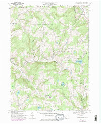
1967 Map of Little Meadows
USGS Topo · Published 1978About this map
The rolling highlands of the Susquehanna and Bradford County border are meticulously charted in this topographic record, reflecting the rural character of the Pennsylvania-New York state line in the late 1960s. The landscape is defined by the winding course of Wappasening Creek and Apalachin Creek, which carve deep valleys between wooded ridges. Small agricultural and residential clusters like Little Meadows and Warren Center serve as the primary hubs, anchored by local institutions such as St Thomas Ch and the Township Sch.
Find a feature on this map
42 named features on this map. Tap any name to fly to it.
Don’t see what you’re looking for? This feature index may not catch every label — zoom into the map to look around manually.
Map Details
Editions of this 1967 Little Meadows Map
Other maps of this area

1901 · Apalachin
USGS Topo · 1:62,500

1903 · Owego
USGS Topo · 1:62,500

1904 · Apalachin
USGS Topo · 1:62,500

1906 · Catatonk
USGS Topo · 1:125,000

1923 · Towanda
USGS Topo · 1:62,500

1926 · Towanda
USGS Topo · 1:62,500

1943 · Towanda
USGS Topo · 1:62,500

1943 · Le Raysville
USGS Topo · 1:62,500

1945 · Le Raysville
USGS Topo · 1:62,500

1950 · Elmira
USGS Topo · 1:250,000