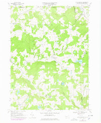
1967 Map of Little Meadows
USGS Topo · Published 1978About this map
Little Meadows anchors the northern edge of this Susquehanna County landscape, where the New York border meets the rural townships of Warren and Apolacon. The 1967 terrain reflects a classic Endless Mountains settlement pattern, where small clusters like Warren Center and South Warren are interconnected by winding valley roads following watercourses such as Wappasening Creek and Apalachin Creek. The map documents a community defined by its landmarks and land use, including the Township Sch, St Thomas Ch, and several family-named burial grounds like the Coburn-Dewing Cem.
Find a feature on this map
45 named features on this map. Tap any name to fly to it.
Don’t see what you’re looking for? This feature index may not catch every label — zoom into the map to look around manually.
Map Details
Editions of this 1967 Little Meadows Map
Other maps of this area

1901 · Apalachin
USGS Topo · 1:62,500

1903 · Owego
USGS Topo · 1:62,500

1904 · Apalachin
USGS Topo · 1:62,500

1906 · Catatonk
USGS Topo · 1:125,000

1923 · Towanda
USGS Topo · 1:62,500

1926 · Towanda
USGS Topo · 1:62,500

1943 · Towanda
USGS Topo · 1:62,500

1943 · Le Raysville
USGS Topo · 1:62,500

1945 · Le Raysville
USGS Topo · 1:62,500

1950 · Elmira
USGS Topo · 1:250,000