
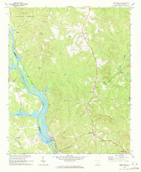
1971 Map of Little Mountain
USGS Topo · Published 1974About this map
Little Mountain rises as a prominent landmark in this 1971 survey of the Piedmont, where the boundary between Newberry Co and Lexington Co winds through a landscape of creek valleys and small rural hubs. The southern portion of the map is defined by the irregular northern fingers of Lake Murray, showing the inundated shoreline around Fairview and the mouth of Buffalo Creek. This era of the landscape is characterized by a network of established country churches, such as St Peters Ch and Mt Tabor Ch, which served the scattered farming communities of Wheeland and Kibler.
Find a feature on this map
41 named features on this map. Tap any name to fly to it.
Don’t see what you’re looking for? This feature index may not catch every label — zoom into the map to look around manually.
Map Details
Editions of this 1971 Little Mountain Map
2 editions found

Other maps of this area

1904 · Columbia
USGS Topo · 1:125,000

1941 · Spartanburg
USGS Topo · 1:250,000

1953 · Spartanburg
USGS Topo · 1:250,000

1960 · Spartanburg
USGS Topo · 1:250,000

1963 · Spartanburg
USGS Topo · 1:250,000

1964 · Spartanburg
USGS Topo · 1:250,000

1968 · Newberry East
USGS Topo · 1:24,000

1969 · Pomaria
USGS Topo · 1:24,000
1969 · Jenkinsville
USGS Topo · 1:24,000

1970 · Prosperity
USGS Topo · 1:24,000