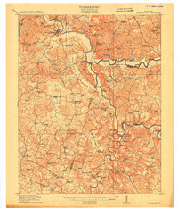
1914 Map of Little Muddy
USGS Topo · Published 1914About this map
Morgantown and Woodbury anchor this 1914 survey of the central Kentucky river country, where the Green River and Barren River served as the primary arteries for commerce. The landscape is heavily marked by river-dependent infrastructure, including numerous landings such as Foster Landing and Millshed Landing, and active crossings like the Fannie Roan Ferry. A high density of rural schools, such as Little Muddy School and Sugar Grove School, reveals a well-populated agricultural interior connected by historic thoroughfares like the Brownsville Road and Greenville Road.
Find a feature on this map
107 named features on this map. Tap any name to fly to it.
Don’t see what you’re looking for? This feature index may not catch every label — zoom into the map to look around manually.
Map Details
Editions of this 1914 Little Muddy Map
4 editions found
Other maps of this area

1909 · Hartford
USGS Topo · 1:62,500

1911 · Dunmor
USGS Topo · 1:48,000

1914 · Little Muddy
USGS Topo · 1:62,500

1914 · Dunmor
USGS Topo · 1:62,500

1921 · Bowling Green
USGS Topo · 1:62,500

1922 · Leitchfield
USGS Topo · 1:48,000

1922 · Brownsville
USGS Topo · 1:62,500

1923 · Bowling Green
USGS Topo · 1:62,500

1923 · Brownsville
USGS Topo · 1:62,500

1925 · Spring Lick
USGS Topo · 1:62,500