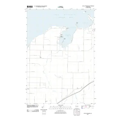
2010 Map of Little Sturgeon
USGS Topo · Published 2010About this map
Little Sturgeon Bay and Rileys Bay define this coastal stretch of Door County, where the settlement of Little Sturgeon sits sheltered by Henderson Point. The landscape is a mix of agricultural fields and wooded shoreline, with Brussels Hill rising to the south. Local heritage is preserved in several rural burial grounds, including Stevenson Cemetery near the coast and Saint Joseph Cemetery further inland. The map details a complex network of drainage and small waterways, such as the winding path of Keyes Creek and the headwaters of the Ahnapee River. Islands like Snake Island and Squaw Island remain prominent features of the Green Bay coast, while roads like Lime Kiln Rd and Stevenson Pier Rd reflect the area's long-standing connection to maritime and industrial activities.
Find a feature on this map
56 named features on this map. Tap any name to fly to it.
Don’t see what you’re looking for? This feature index may not catch every label — zoom into the map to look around manually.
Map Details
Editions of this 2010 Little Sturgeon Map
This is the sole edition of this map. No revisions or reprints were ever made.
Other maps of this area

1952 · Casco
USGS Topo · 1:62,500

1954 · Manitowoc
USGS Topo · 1:250,000

1958 · Manitowoc
USGS Topo · 1:250,000

1960 · Sturgeon Bay
USGS Topo · 1:62,500

1960 · Algoma
USGS Topo · 1:62,500

1961 · Little Sturgeon
USGS Topo · 1:62,500
1974 · Peshtigo Harbor
USGS Topo · 1:24,000

1978 · Namur
USGS Topo · 1:24,000

1978 · Brussels
USGS Topo · 1:24,000

1981 · Sturgeon Bay West
USGS Topo · 1:24,000