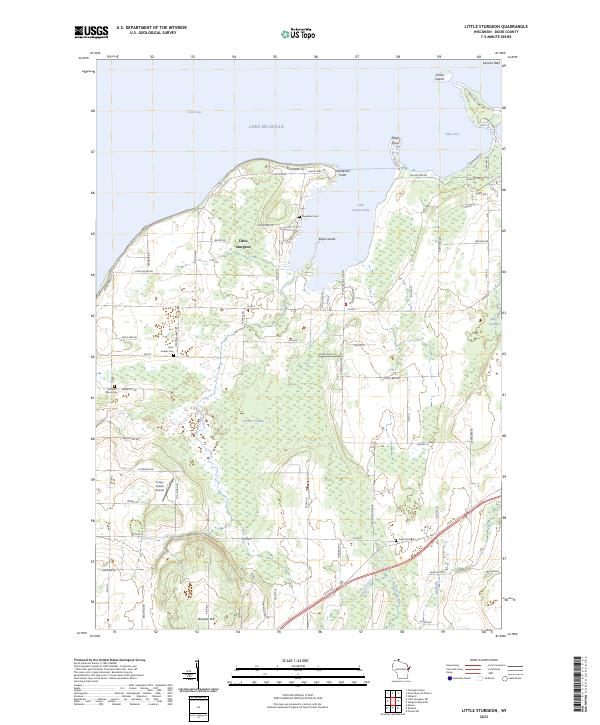
2023 Map of Little Sturgeon
USGS Topo · Published 2023About this map
Little Sturgeon sits at the base of its namesake bay on this modern survey of Door County's southwestern coast along Green Bay. The landscape is a mosaic of low-lying wetlands and limestone-influenced uplands, dominated by the expansive Gardner Swamp and the headwaters of the Ahnapee River. For genealogists, the map preserves the locations of several burial grounds, including Saint Joseph Cem near the central crossroads and Precious Blood Cem further west, along with family-named landmarks like Brussels Hill and Henderson Point. The irregular coastline is defined by features such as Keyes Island and Rileys Point, showing the intricate shoreline that has long supported both local maritime life and residential development. Modern additions like the Crispy Cedars Airport appear alongside older transport corridors like Tornado Rd, indicating how this rural area continues to evolve while maintaining its agrarian and coastal character.
Find a feature on this map
84 named features on this map. Tap any name to fly to it.
Don’t see what you’re looking for? This feature index may not catch every label — zoom into the map to look around manually.
Map Details
Editions of this 2023 Little Sturgeon Map
This is the sole edition of this map. No revisions or reprints were ever made.
Other maps of this area

1952 · Casco
USGS Topo · 1:62,500

1954 · Manitowoc
USGS Topo · 1:250,000

1958 · Manitowoc
USGS Topo · 1:250,000

1960 · Sturgeon Bay
USGS Topo · 1:62,500

1960 · Algoma
USGS Topo · 1:62,500

1961 · Little Sturgeon
USGS Topo · 1:62,500
1974 · Peshtigo Harbor
USGS Topo · 1:24,000

1978 · Namur
USGS Topo · 1:24,000

1978 · Brussels
USGS Topo · 1:24,000

1981 · Sturgeon Bay West
USGS Topo · 1:24,000