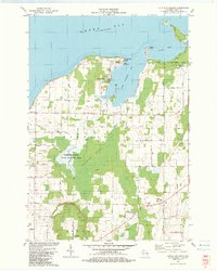
1982 Map of Little Sturgeon
USGS Topo · Published 1983About this map
Little Sturgeon Bay and the northern reaches of the Ahnapee River define this corner of the Door Peninsula in the early 1980s. The landscape is a mix of coastal access and heavy interior wetlands, dominated by the massive Gardner Swamp State Wildlife Area. To the north, Little Sturgeon sits near the base of the peninsula forming Henderson Point, while the southern end of the map reveals the village of Forestville and the modern campus of Southern Door High Sch. Historically significant sites like Tornado Memorial County Park and the Stevenson Cem provide specific points of interest for local researchers. The shoreline is well-documented from Snake Island down to Rileys Point, showing the development of coastal roads like Sand Bay Road and Claflin Rd as they navigate the rocky inlets and bays of Green Bay.
Find a feature on this map
60 named features on this map. Tap any name to fly to it.
Don’t see what you’re looking for? This feature index may not catch every label — zoom into the map to look around manually.
Map Details
Editions of this 1982 Little Sturgeon Map
This is the sole edition of this map. No revisions or reprints were ever made.
Other maps of this area

1952 · Casco
USGS Topo · 1:62,500

1954 · Manitowoc
USGS Topo · 1:250,000

1958 · Manitowoc
USGS Topo · 1:250,000

1960 · Sturgeon Bay
USGS Topo · 1:62,500

1960 · Algoma
USGS Topo · 1:62,500

1961 · Little Sturgeon
USGS Topo · 1:62,500
1974 · Peshtigo Harbor
USGS Topo · 1:24,000

1978 · Namur
USGS Topo · 1:24,000

1978 · Brussels
USGS Topo · 1:24,000

1981 · Sturgeon Bay West
USGS Topo · 1:24,000