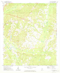
1971 Map of Little Texas
USGS Topo · Published 1973About this map
Tuskegee National Forest dominates the northwest quadrant of this terrain, where the landscape transitions from the wooded ridges of the forest into an area of scattered rural settlements and small-scale industry. The namesake community of Little Texas serves as a central landmark, surrounded by a network of local churches that define the social geography of the era, including Oak Grove Ch, Hickory Grove Ch, and Pine Grove Ch.
Find a feature on this map
27 named features on this map. Tap any name to fly to it.
Don’t see what you’re looking for? This feature index may not catch every label — zoom into the map to look around manually.
Map Details
Editions of this 1971 Little Texas Map
2 editions found
Other maps of this area

1906 · Dadeville
USGS Topo · 1:125,000

1907 · Opelika
USGS Topo · 1:125,000

1909 · Opelika
USGS Topo · 1:125,000

1955 · Phenix City
USGS Topo · 1:250,000

1957 · Phenix City
USGS Topo · 1:250,000

1958 · Phenix City
USGS Topo · 1:250,000

1971 · Little Texas
USGS Topo · 1:24,000

1971 · Loachapoka
USGS Topo · 1:24,000

1971 · Tuskegee
USGS Topo · 1:24,000
1971 · Society Hill
USGS Topo · 1:24,000