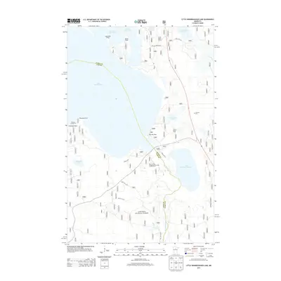
2013 Map of Little Winnibigoshish Lake
USGS Topo · Published 2013About this map
Lake Winnibigoshish and the headwaters of the Mississippi River dominate this portion of the Chippewa National Forest on the border of Itasca and Cass counties. The landscape is defined by its complex shoreline, featuring prominent landmarks like Sugarbush Point, Battle Point, and Inspiration Point along the expansive waters. This modern survey shows the intricate network of forest routes and local roads, such as Williams Narrows Rd and Bowens Rd, that provide access to the region's recreational hubs. Significant sites for local history and public use include the Fairbanks Cem, the Winnie Lookout Tower, and extensive visitor facilities at the Plug Hat Point Campground Recreation and Picnic Area. The map captures the meeting of major water bodies, including Little Winnibigoshish Lake and Cut Foot Sioux Lake, documenting the vital hydrologic and recreational character of this northern Minnesota timber and lake district.
Find a feature on this map
26 named features on this map. Tap any name to fly to it.
Don’t see what you’re looking for? This feature index may not catch every label — zoom into the map to look around manually.
Map Details
Editions of this 2013 Little Winnibigoshish Lake Map
This is the sole edition of this map. No revisions or reprints were ever made.
Other maps of this area

1919 · Max
USGS Topo · 1:62,500

1954 · Bemidji
USGS Topo · 1:250,000

1954 · Hibbing
USGS Topo · 1:250,000

1957 · Bemidji
USGS Topo · 1:250,000

1957 · Hibbing
USGS Topo · 1:250,000

1958 · Bemidji
USGS Topo · 1:250,000

1958 · Hibbing
USGS Topo · 1:250,000

1964 · Hibbing
USGS Topo · 1:250,000

1970 · Bowstring Lake
USGS Topo · 1:24,000

1970 · Ball Club
USGS Topo · 1:24,000