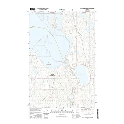
2016 Map of Little Winnibigoshish Lake
USGS Topo · Published 2016About this map
The Chippewa National Forest dominates this northern Minnesota landscape, where the waters of the Mississippi River flow between Lake Winnibigoshish and Little Winnibigoshish Lake. This 2016 survey illustrates the intricate shoreline of the Cut Foot Sioux Lake system, including McAvity Bay and the prominent Sugarbush Point. The map reveals a region defined by its hydrology and recreation, featuring numerous smaller bodies of water like Schoolhouse Lake and Tamarack Lake. Land use is primarily focused on timber management and seasonal access, marked by a network of forest routes and the Avenue of Pines Snowmobile Tr. Local history is anchored at the Fairbanks Cem near the eastern forest edge. The intricate network of trails, such as the Winnie Snowmobile Trail, highlights the area's role as a destination for winter transit and outdoor exploration within the national forest boundaries.
Find a feature on this map
33 named features on this map. Tap any name to fly to it.
Don’t see what you’re looking for? This feature index may not catch every label — zoom into the map to look around manually.
Map Details
Editions of this 2016 Little Winnibigoshish Lake Map
This is the sole edition of this map. No revisions or reprints were ever made.
Other maps of this area

1919 · Max
USGS Topo · 1:62,500

1954 · Bemidji
USGS Topo · 1:250,000

1954 · Hibbing
USGS Topo · 1:250,000

1957 · Bemidji
USGS Topo · 1:250,000

1957 · Hibbing
USGS Topo · 1:250,000

1958 · Bemidji
USGS Topo · 1:250,000

1958 · Hibbing
USGS Topo · 1:250,000

1964 · Hibbing
USGS Topo · 1:250,000

1970 · Bowstring Lake
USGS Topo · 1:24,000

1970 · Ball Club
USGS Topo · 1:24,000