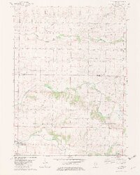
1982 Map of Little York
USGS Topo · Published 1983About this map
The village of Little York sits at the southwestern edge of this 1982 survey, serving as a hub for the agricultural lands of Sumner and Spring Grove townships. The landscape is defined by the drainage networks of Henderson Creek and its tributaries, including Middle Henderson Creek and Cedar Creek, which cut through the fertile till plains. Evidence of earlier transportation infrastructure is visible in the north and east, where an Old Railroad Grade bypasses established hamlets like Norwood and Shaw.
Find a feature on this map
29 named features on this map. Tap any name to fly to it.
Don’t see what you’re looking for? This feature index may not catch every label — zoom into the map to look around manually.
Map Details
Editions of this 1982 Little York Map
2 editions found
Other maps of this area

1921 · Monmouth
USGS Topo · 1:62,500

1923 · Monmouth
USGS Topo · 1:62,500

1923 · Alexis
USGS Topo · 1:62,500

1925 · Alexis
USGS Topo · 1:62,500

1934 · Oquawka
USGS Topo · 1:48,000

1935 · Keithsburg
USGS Topo · 1:48,000

1940 · Oquawka
USGS Topo · 1:62,500

1941 · Keithsburg
USGS Topo · 1:62,500

1953 · Viola
USGS Topo · 1:24,000
1953 · Aledo East
USGS Topo · 1:24,000