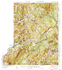
1935 Map of Littleton
USGS Topo · Published 1935About this map
The Connecticut River serves as the winding boundary between Vermont and New Hampshire in the mid-1930s, anchoring a landscape defined by its river-and-rail economy. The presence of the Frank D. Comerford Hydro-electric Plant near Monroe highlights the industrial shift toward electrification along the river's edge. This era is characterized by an extensive network of rural education, evidenced by numerous local schoolhouses such as Sugar Hill Sch and North Littleton Sch that once served these upland farming and timber communities.
Find a feature on this map
98 named features on this map. Tap any name to fly to it.
Don’t see what you’re looking for? This feature index may not catch every label — zoom into the map to look around manually.
Map Details
Editions of this 1935 Littleton Map
4 editions found

Other maps of this area

1900 · Whitefield
USGS Topo · 1:62,500

1920 · Guildhall
USGS Topo · 1:62,500

1929 · Moosilauke
USGS Topo · 1:62,500

1929 · Franconia
USGS Topo · 1:62,500

1931 · Guildhall
USGS Topo · 1:48,000

1931 · Littleton
USGS Topo · 1:62,500

1931 · Woodsville
USGS Topo · 1:48,000

1932 · Franconia
USGS Topo · 1:62,500

1932 · Littleton
USGS Topo · 1:48,000

1932 · Moosilauke
USGS Topo · 1:62,500