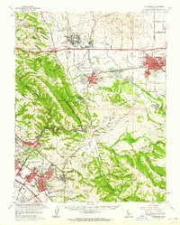
1961 Map of Livermore
USGS Topo · Published 1962About this map
Livermore and Pleasanton serve as the primary hubs in this early 1960s study of eastern Alameda County. The landscape is a mix of rapidly expanding suburban districts and significant institutional holdings. Large-scale installations such as Camp Parks, the Military Reservation, and the Vallecitos Atomic Laboratory occupy substantial acreage between the rolling ridges. To the west, the integration of Fremont is visible through its constituent parts, including the Niles District, Centerville Dist, and the Mission San Jose District, where St Mary of the Palms stands. The era's transportation infrastructure is well-defined, featuring the Nimitz Freeway and a dense network of Southern Pacific and Western Pacific rail lines. Notable local landmarks like the Santa Rita Rehabilitation Center and Castlewood Country Club provide clear reference points for the mid-century development of the Amador and Livermore Valleys.
Find a feature on this map
72 named features on this map. Tap any name to fly to it.
Don’t see what you’re looking for? This feature index may not catch every label — zoom into the map to look around manually.
Map Details
Editions of this 1961 Livermore Map
2 editions found
Other maps of this area

1889 · San Jose
USGS Topo · 1:62,500

1896 · Mt. Diablo
USGS Topo · 1:62,500

1897 · San Jose
USGS Topo · 1:62,500

1897 · Mt. Hamilton
USGS Topo · 1:62,500

1897 · Concord
USGS Topo · 1:62,500

1897 · Palo Alto
USGS Topo · 1:62,500

1898 · Mt. Diablo
USGS Topo · 1:62,500

1899 · San Jose
USGS Topo · 1:62,500

1899 · Palo Alto
USGS Topo · 1:62,500

1899 · Haywards
USGS Topo · 1:62,500