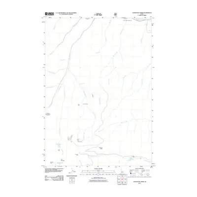
2011 Map of Livingston Creek
USGS Topo · Published 2011About this map
Livingston Mine and the Livingston Mill anchor this high-altitude mining landscape in Custer County. The 2011 survey reveals an intensive history of mineral extraction throughout the drainage basins of Livingston Creek and Silver Rule Creek. At elevations reaching toward Railroad Ridge, a network of historical operations includes the Silver Rute Mine, Tango Mine, and the Little Livingston Mine. These sites are linked by the rugged topography of the Chinese Wall and The Gunsight, demonstrating the extreme conditions faced by prospectors in the region. To the north, the Salmon River flows near the Holman Creek Campground, where the wilderness character of the State Creek Rd corridor contrasts with the industrial footprint of the Hoodoo Mine Number One Dam. Natural features like Crater Lake and Gunsight Lake sit tucked below steep ridges, serving as landmarks within this remote backcountry.
Find a feature on this map
35 named features on this map. Tap any name to fly to it.
Don’t see what you’re looking for? This feature index may not catch every label — zoom into the map to look around manually.
Map Details
Editions of this 2011 Livingston Creek Map
This is the sole edition of this map. No revisions or reprints were ever made.
Other maps of this area

1919 · Custer
USGS Topo · 1:125,000

1922 · Custer
USGS Topo · 1:125,000

1929 · Bayhorse
USGS Topo · 1:125,000

1957 · Challis
USGS Topo · 1:250,000

1960 · Challis
USGS Topo · 1:250,000

1963 · Challis
USGS Topo · 1:250,000

1963 · Clayton
USGS Topo · 1:24,000
1963 · Potaman Peak
USGS Topo · 1:24,000

1963 · Clayton
USGS Topo · 1:62,500
1963 · Bowery Creek
USGS Topo · 1:24,000