1963 Map of Bowery Creek
USGS Topo · Published 1965About this map
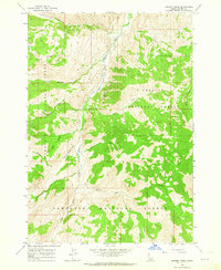
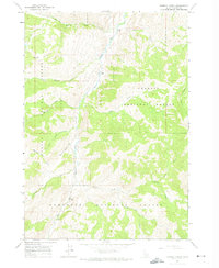
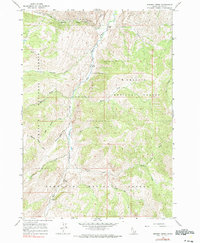
The East Fork Salmon River carves a deep valley through this portion of Custer County, serving as the primary geographical corridor for the region. In the early 1960s, this landscape was defined by its transition between the Challis National Forest and Sawtooth National Forest. A notable human element in this otherwise wilderness-dominated area is the Landing Strip located along the riverbanks, providing essential aerial access to these remote reaches. The drainage network is dense, with numerous tributaries such as Big Boulder Creek, Little Boulder Creek, and Bowery Creek flowing from the high elevations of Red Ridge. The lack of established road infrastructure on this map highlights the area's isolation and its reliance on the river valley and small airstrips for movement and connectivity.
Find a feature on this map
17 named features on this map. Tap any name to fly to it.
Don’t see what you’re looking for? This feature index may not catch every label — zoom into the map to look around manually.
Map Details
Editions of this 1963 Bowery Creek Map
3 editions found
Other maps of this area

1895 · Hailey
USGS Topo · 1:125,000

1897 · Hailey
USGS Topo · 1:125,000

1900 · Sawtooth
USGS Topo · 1:125,000

1919 · Custer
USGS Topo · 1:125,000

1922 · Custer
USGS Topo · 1:125,000

1929 · Bayhorse
USGS Topo · 1:125,000

1955 · Hailey
USGS Topo · 1:250,000

1957 · Challis
USGS Topo · 1:250,000

1959 · Hailey
USGS Topo · 1:250,000

1960 · Challis
USGS Topo · 1:250,000