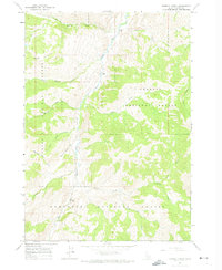
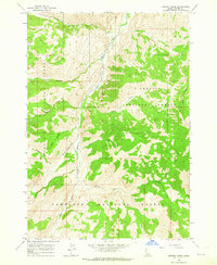
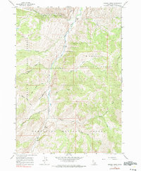
1963 Map of Bowery Creek
USGS Topo · Published 1974About this map
The East Fork Salmon River carves a deep path through the high country of Custer County, Idaho, during the early 1960s. This survey captures a rugged landscape where the river is the primary navigational artery, flanked by a series of significant tributaries including Big Boulder Creek and Little Boulder Creek in the north, and Germania Creek and Bowery Creek further south. The presence of a remote Landing Strip near the river's edge, situated between the Challis National Forest and the Sawtooth National Forest, highlights the area's isolation and its reliance on small aircraft for access. The terrain is defined by dramatic elevations such as Red Ridge and intricate drainages like Mountain Meadow Creek and Long Tom Creek, reflecting a wilderness defined by forestry and high-altitude watershed management.
Find a feature on this map
17 named features on this map. Tap any name to fly to it.
Don’t see what you’re looking for? This feature index may not catch every label — zoom into the map to look around manually.
Map Details
Editions of this 1963 Bowery Creek Map
3 editions found
Other maps of this area

1895 · Hailey
USGS Topo · 1:125,000

1897 · Hailey
USGS Topo · 1:125,000

1900 · Sawtooth
USGS Topo · 1:125,000

1919 · Custer
USGS Topo · 1:125,000

1922 · Custer
USGS Topo · 1:125,000

1929 · Bayhorse
USGS Topo · 1:125,000

1955 · Hailey
USGS Topo · 1:250,000

1957 · Challis
USGS Topo · 1:250,000

1959 · Hailey
USGS Topo · 1:250,000

1960 · Challis
USGS Topo · 1:250,000