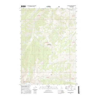
2017 Map of Livingston Creek
USGS Topo · Published 2017About this map
Challis National Forest dominates this high-elevation terrain in Custer County, where the topography reaches its most dramatic heights along the Chinese Wall and The Gunsight. This 2017 survey reveals a landscape defined by sharp glacial features and alpine basins, containing numerous high-altitude water bodies such as Crater Lake, Dike Lake, and Gunsight Lake. The drainage network is complex, with Livingston Cr and Big Boulder Cr flowing through the southern reaches, while the northern edge is bounded by the Salmon River. An interesting historical marker of land use is found at Railroad Ridge, a prominent feature that suggests the high-country travel routes of the past. The map also detail numerous small tributaries like Silver Rule Cr and Carbonate Cr, which cut through the steep slopes of the Salmon River Mountains.
Find a feature on this map
54 named features on this map. Tap any name to fly to it.
Don’t see what you’re looking for? This feature index may not catch every label — zoom into the map to look around manually.
Map Details
Editions of this 2017 Livingston Creek Map
This is the sole edition of this map. No revisions or reprints were ever made.
Other maps of this area

1919 · Custer
USGS Topo · 1:125,000

1922 · Custer
USGS Topo · 1:125,000

1929 · Bayhorse
USGS Topo · 1:125,000

1957 · Challis
USGS Topo · 1:250,000

1960 · Challis
USGS Topo · 1:250,000

1963 · Challis
USGS Topo · 1:250,000

1963 · Clayton
USGS Topo · 1:24,000
1963 · Potaman Peak
USGS Topo · 1:24,000

1963 · Clayton
USGS Topo · 1:62,500
1963 · Bowery Creek
USGS Topo · 1:24,000