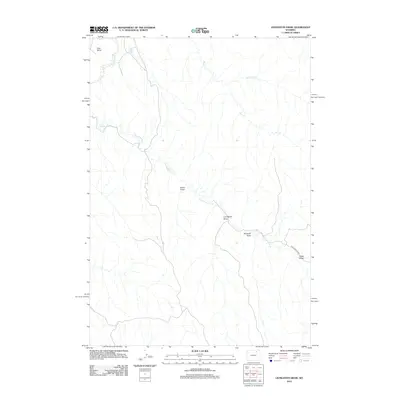
2012 Map of Livingston Draw
USGS Topo · Published 2012About this map
The Powder River carves through this portion of Campbell County, defining a landscape of deep drainages and intermittent watercourses. In this high plains environment, the naming of features like Coal Draw and Windmill Draw reflects the region's reliance on both its mineral resources and the essential infrastructure for ranching. Fortification Cr meanders through the central terrain, joined by a network of tributaries including Bull Cr and Little Bull Cr. This 2012 survey illustrates the modern transportation footprint in a sparsely populated area, where Fortification Rd serves as the primary artery connecting the various draws. The topography around Livingston Draw and Cedar Draw reveals the complex erosion patterns typical of the Powder River Basin, providing a detailed record of the land surface before further energy or agricultural development.
Find a feature on this map
10 named features on this map. Tap any name to fly to it.
Don’t see what you’re looking for? This feature index may not catch every label — zoom into the map to look around manually.
Map Details
Editions of this 2012 Livingston Draw Map
This is the sole edition of this map. No revisions or reprints were ever made.
Other maps of this area

1954 · Gillette
USGS Topo · 1:250,000

1955 · Sheridan
USGS Topo · 1:250,000

1955 · Gillette
USGS Topo · 1:250,000

1958 · Gillette
USGS Topo · 1:250,000

1958 · Sheridan
USGS Topo · 1:250,000

1962 · Gillette
USGS Topo · 1:250,000

1962 · Sheridan
USGS Topo · 1:250,000

1972 · Mitchell Draw
USGS Topo · 1:24,000
1972 · Carr Draw
USGS Topo · 1:24,000
1972 · Lariat
USGS Topo · 1:24,000