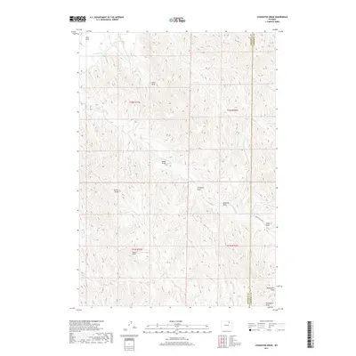
2017 Map of Livingston Draw
USGS Topo · Published 2017About this map
The Powder River cuts through the northwest corner of this Campbell County landscape, marking a significant hydrologic feature in a region defined by complex drainage systems. The terrain is dominated by the Kinney Divide, where numerous ephemeral waterways and draws originate. Notable among these are Livingston Draw, Indian Draw, and Windmill Draw, which feed into larger tributaries like Fortification Cr. These features reflect a traditional high-plains geography where water management and seasonal flows dictate the movement across the land.
Find a feature on this map
19 named features on this map. Tap any name to fly to it.
Don’t see what you’re looking for? This feature index may not catch every label — zoom into the map to look around manually.
Map Details
Editions of this 2017 Livingston Draw Map
This is the sole edition of this map. No revisions or reprints were ever made.
Other maps of this area

1954 · Gillette
USGS Topo · 1:250,000

1955 · Sheridan
USGS Topo · 1:250,000

1955 · Gillette
USGS Topo · 1:250,000

1958 · Gillette
USGS Topo · 1:250,000

1958 · Sheridan
USGS Topo · 1:250,000

1962 · Gillette
USGS Topo · 1:250,000

1962 · Sheridan
USGS Topo · 1:250,000

1972 · Mitchell Draw
USGS Topo · 1:24,000
1972 · Carr Draw
USGS Topo · 1:24,000
1972 · Lariat
USGS Topo · 1:24,000