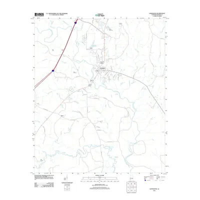
2011 Map of Livingston
USGS Topo · Published 2011About this map
Livingston serves as the focal point of this Sumter County landscape, anchored by the University of West Alabama campus. The town's layout is defined by the winding path of the Sucarnochee River, which cuts through the center of the quadrangle, joined by tributaries like Potts Creek and Whiterock Creek. The map reflects a community deeply connected to its local geography, with residential areas like Northside Vlg and institutional landmarks including the Livingston Post Office and Livingston Memorial Gardens.
Find a feature on this map
64 named features on this map. Tap any name to fly to it.
Don’t see what you’re looking for? This feature index may not catch every label — zoom into the map to look around manually.
Map Details
Editions of this 2011 Livingston Map
This is the sole edition of this map. No revisions or reprints were ever made.
Other maps of this area

1929 · Epes
USGS Topo · 1:48,000

1932 · Epes
USGS Topo · 1:62,500

1953 · Meridian
USGS Topo · 1:250,000

1957 · Meridian
USGS Topo · 1:250,000

1965 · Meridian
USGS Topo · 1:250,000

1971 · Coatopa
USGS Topo · 1:24,000

1971 · Bellamy
USGS Topo · 1:24,000

1974 · Boyd
USGS Topo · 1:24,000
1974 · Epes West
USGS Topo · 1:24,000
1974 · Epes East
USGS Topo · 1:24,000