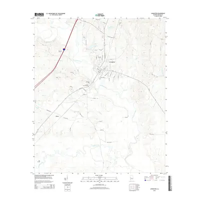
2014 Map of Livingston
USGS Topo · Published 2014About this map
The Univ of W Alabama campus serves as the cultural and academic heart of Livingston, situated where the Sucarnochee River meets a network of smaller tributaries. This 2014 survey documents the town's street grid and its relationship with the surrounding Sumter County landscape, characterized by the convergence of Sandy Cr, Potts Cr, and Holebah Cr. The map provides significant genealogical value through its marking of local burial grounds, including the Houston Cem near Ennis Tartt Pond and the Potts Cem west of the river. The topography transitions from the developed campus around Lake LU to the more rural areas of Hixon and The Cutoff. Notable landmarks like Baldwin Hill and the Livingston Memorial Gardens offer points of interest for local historians studying the town's modern geography and institutional footprint.
Find a feature on this map
67 named features on this map. Tap any name to fly to it.
Don’t see what you’re looking for? This feature index may not catch every label — zoom into the map to look around manually.
Map Details
Editions of this 2014 Livingston Map
This is the sole edition of this map. No revisions or reprints were ever made.
Other maps of this area

1929 · Epes
USGS Topo · 1:48,000

1932 · Epes
USGS Topo · 1:62,500

1953 · Meridian
USGS Topo · 1:250,000

1957 · Meridian
USGS Topo · 1:250,000

1965 · Meridian
USGS Topo · 1:250,000

1971 · Coatopa
USGS Topo · 1:24,000

1971 · Bellamy
USGS Topo · 1:24,000

1974 · Boyd
USGS Topo · 1:24,000
1974 · Epes West
USGS Topo · 1:24,000
1974 · Epes East
USGS Topo · 1:24,000