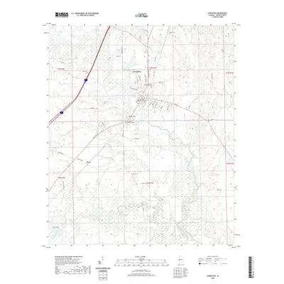
2020 Map of Livingston
USGS Topo · Published 2020About this map
The Sucarnoochie River and its many tributaries, including Shumulla Cr and Holetah Cr, define the drainage and topography of this western Alabama landscape. At the center of this 2020 survey is Livingston, anchored by the University of West Alabama and the Sumter County Courthouse. The map reveals a transition from the urban grid of the town to the surrounding wetlands and creek bottoms, where family and community heritage is preserved at sites like Potts Cem, Johnson Cem, and Houston Cem. South of the main settlement, the land rises toward Baldwin Hill before dropping into the broad floodplain of Alamuchee Creek, which is marked by distinctive hydrological features such as The Cutoff. The survey provides a clear view of the modern road network, including the intersection of Lafayette St and North St, while maintaining the names of smaller water bodies like Hannah Br and Bibbs Br that have long shaped local geography.
Find a feature on this map
69 named features on this map. Tap any name to fly to it.
Don’t see what you’re looking for? This feature index may not catch every label — zoom into the map to look around manually.
Map Details
Editions of this 2020 Livingston Map
This is the sole edition of this map. No revisions or reprints were ever made.
Other maps of this area

1929 · Epes
USGS Topo · 1:48,000

1932 · Epes
USGS Topo · 1:62,500

1953 · Meridian
USGS Topo · 1:250,000

1957 · Meridian
USGS Topo · 1:250,000

1965 · Meridian
USGS Topo · 1:250,000

1971 · Coatopa
USGS Topo · 1:24,000

1971 · Bellamy
USGS Topo · 1:24,000

1974 · Boyd
USGS Topo · 1:24,000
1974 · Epes West
USGS Topo · 1:24,000
1974 · Epes East
USGS Topo · 1:24,000