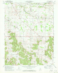
1970 Map of Livonia
USGS Topo · Published 1972About this map
Livonia anchors this 1970 landscape where the limestone topography of Southern Indiana creates a complex drainage pattern defined by the Lost River. The map captures a transition from the agricultural plains of Bromer and Claysville in the north to the deeply dissected terrain of the Hoosier National Forest in the southwest. A notable geographic feature is the subterranean nature of the region's water, evidenced by labels such as Sinking Spring, where surface water disappears into the karst network.
Find a feature on this map
36 named features on this map. Tap any name to fly to it.
Don’t see what you’re looking for? This feature index may not catch every label — zoom into the map to look around manually.
Map Details
Editions of this 1970 Livonia Map
This is the sole edition of this map. No revisions or reprints were ever made.
Other maps of this area

1947 · Hardinsburg
USGS Topo · 1:24,000

1949 · Hardinsburg
USGS Topo · 1:24,000

1950 · Becks Mill
USGS Topo · 1:24,000

1950 · Mitchell
USGS Topo · 1:24,000

1950 · Valeene
USGS Topo · 1:24,000

1951 · Smedley
USGS Topo · 1:24,000

1953 · Fredericksburg
USGS Topo · 1:24,000

1956 · Vincennes
USGS Topo · 1:250,000

1957 · Vincennes
USGS Topo · 1:250,000

1957 · Campbellsburg
USGS Topo · 1:24,000