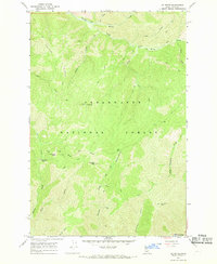
1966 Map of Liz Butte
USGS Topo · Published 1969About this map
Clearwater National Forest dominates this mid-1960s survey, revealing a landscape defined by high ridges and a complex system of drainage creeks. The terrain is marked by significant elevations such as Liz Butte and Sherman Peak, which served as critical vantage points for forestry and fire management, evidenced by the Lookout Liz Butte station. An intricate network of Pack Trails provides the primary means of traversal through these steep slopes, connecting remote features like Sherman Saddle and the curiously named No-see-um Meadows. In the southern portion of the quadrangle, the terrain drops toward the Lochsa River corridor, while the north is defined by the prominent Weitas Ridge. This map illustrates the primitive infrastructure of the national forest system before modern road development, where access relied on seasonal trails and topographic landmarks like Chimney Butte and Bald Mountain.
Find a feature on this map
25 named features on this map. Tap any name to fly to it.
Don’t see what you’re looking for? This feature index may not catch every label — zoom into the map to look around manually.
Map Details
Editions of this 1966 Liz Butte Map
2 editions found
Other maps of this area

1911 · Lolo
USGS Topo · 1:250,000

1913 · Lolo
USGS Topo · 1:250,000

1956 · Hamilton
USGS Topo · 1:250,000

1959 · Hamilton
USGS Topo · 1:250,000

1960 · Hamilton
USGS Topo · 1:250,000

1964 · Hamilton
USGS Topo · 1:250,000

1965 · Lean-to Point
USGS Topo · 1:24,000

1965 · Lookout Peak
USGS Topo · 1:24,000
1965 · Cook Mountain
USGS Topo · 1:24,000
1966 · Weitas Butte
USGS Topo · 1:24,000