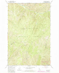
1966 Map of Liz Butte
USGS Topo · Published 1984About this map
Clearwater National Forest dominates this mid-1960s landscape, where a sophisticated network of Pack Trails and the historic Lolo Trail provide the primary access through the high country. The area is defined by sharp elevation changes between peaks like Liz Butte and the deep drainage of the Lochsa River along the southern edge. Human presence is marked by isolated outposts like the Liz Creek Cabin and Dry Camp, or the high vantage point at Lookout Liz Butte. Along the numerous watercourses, such as Weitas Creek and Sherman Creek, the terrain transitions into unique open spaces like No-see-um Meadows. This survey serves as a detailed record of the wilderness infrastructure before modern road developments, preserving the locations of specific saddles, ridges, and camps used by foresters and early travelers in Idaho County.
Find a feature on this map
27 named features on this map. Tap any name to fly to it.
Don’t see what you’re looking for? This feature index may not catch every label — zoom into the map to look around manually.
Map Details
Editions of this 1966 Liz Butte Map
2 editions found
Other maps of this area

1911 · Lolo
USGS Topo · 1:250,000

1913 · Lolo
USGS Topo · 1:250,000

1956 · Hamilton
USGS Topo · 1:250,000

1959 · Hamilton
USGS Topo · 1:250,000

1960 · Hamilton
USGS Topo · 1:250,000

1964 · Hamilton
USGS Topo · 1:250,000

1965 · Lean-to Point
USGS Topo · 1:24,000

1965 · Lookout Peak
USGS Topo · 1:24,000
1965 · Cook Mountain
USGS Topo · 1:24,000
1966 · Weitas Butte
USGS Topo · 1:24,000