
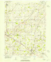
1953 Map of Lizton
USGS Topo · Published 1954About this map
Lizton and Jamestown anchor this mid-century survey of the rural landscape where Boone and Hendricks counties meet. The regional transportation network is defined by the diagonal transit of the New York Central railroad, which links the small settlements of Advance and Raintown. The terrain is deeply inscribed with an intricate system of drainage infrastructure, including the Edlin Ditch, Cunningham Ditch, and Dickey Ditch, reflecting the historical importance of land reclamation for agriculture in this part of Indiana.
Find a feature on this map
40 named features on this map. Tap any name to fly to it.
Don’t see what you’re looking for? This feature index may not catch every label — zoom into the map to look around manually.
Map Details
Editions of this 1953 Lizton Map
2 editions found
Other maps of this area

1953 · Fayette
USGS Topo · 1:24,000

1953 · Danville
USGS Topo · 1:24,000

1953 · Brownsburg
USGS Topo · 1:24,000

1953 · Lebanon
USGS Topo · 1:24,000

1953 · Danville
USGS Topo · 1:250,000

1953 · Indianapolis
USGS Topo · 1:250,000

1955 · Danville
USGS Topo · 1:250,000

1956 · Danville
USGS Topo · 1:250,000

1956 · Indianapolis
USGS Topo · 1:250,000

1957 · Indianapolis
USGS Topo · 1:250,000