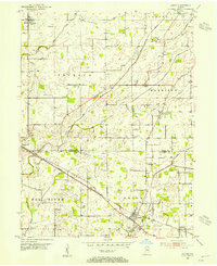
1953 Map of Lizton
USGS Topo · Published 1954About this map
Lizton and Jamestown anchor this mid-century agricultural landscape at the border of Boone and Hendricks counties. The New York Central railroad bisects the terrain, running parallel to the Old State Road and connecting the small rail-stop at Raintown with the larger villages. This era shows a densely settled rural community defined by its family and fraternal associations, evidenced by numerous small burial grounds such as Odd Fellows Cem, Lowry Cem, and Groover Cem.
Find a feature on this map
31 named features on this map. Tap any name to fly to it.
Don’t see what you’re looking for? This feature index may not catch every label — zoom into the map to look around manually.
Map Details
Editions of this 1953 Lizton Map
2 editions found
Other maps of this area

1953 · Fayette
USGS Topo · 1:24,000

1953 · Lizton
USGS Topo · 1:24,000

1953 · Danville
USGS Topo · 1:24,000

1953 · Brownsburg
USGS Topo · 1:24,000

1953 · Lebanon
USGS Topo · 1:24,000

1953 · Danville
USGS Topo · 1:250,000

1953 · Indianapolis
USGS Topo · 1:250,000

1955 · Danville
USGS Topo · 1:250,000

1956 · Danville
USGS Topo · 1:250,000

1956 · Indianapolis
USGS Topo · 1:250,000