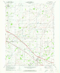
1970 Map of Lizton
USGS Topo · Published 1972About this map
Agricultural lands and rural crossroads define the border between Boone and Hendricks counties in this early 1970s survey. The town of Lizton sits at a transportation juncture, where the Penn Central railroad tracks cut through the landscape near Raintown and the Vieley Cemetery. To the northwest, the community of Jamestown is established along the same rail corridor, surrounded by a network of drainage ditches and creeks including the Middle Fork and Big Walnut Creek. Local education and faith are represented by landmarks such as Wells High School, Pinnell School, and the Old Union Church. The terrain is marked by essential infrastructure of the era, from a network of numbered section roads to the presence of Gravel Pits, a Radio Tower, and several family or community burial grounds like the Groover Cemetery.
Find a feature on this map
52 named features on this map. Tap any name to fly to it.
Don’t see what you’re looking for? This feature index may not catch every label — zoom into the map to look around manually.
Map Details
Editions of this 1970 Lizton Map
This is the sole edition of this map. No revisions or reprints were ever made.
Other maps of this area

1953 · Fayette
USGS Topo · 1:24,000

1953 · Lizton
USGS Topo · 1:24,000

1953 · Danville
USGS Topo · 1:24,000

1953 · Brownsburg
USGS Topo · 1:24,000

1953 · Lebanon
USGS Topo · 1:24,000

1953 · Danville
USGS Topo · 1:250,000

1953 · Indianapolis
USGS Topo · 1:250,000

1955 · Danville
USGS Topo · 1:250,000

1956 · Danville
USGS Topo · 1:250,000

1956 · Indianapolis
USGS Topo · 1:250,000