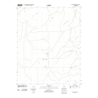
2010 Map of Llonidas Lake
USGS Topo · Published 2010About this map
Llonidas Lake sits at the center of this cattle-ranching landscape in San Miguel County, where the topography is defined by a network of drainage canyons. The map documents a sparsely populated region of New Mexico characterized by family-named landmarks and historical burial grounds such as Mathews Cemetery and Maes Cemetery. The settlement pattern is largely composed of isolated ranching points like Wilson Ranch, Griego, and Crews, all connected by a system of gravel and unimproved roads, including County Road C-53-A. These routes traverse an arid terrain etched by deep seasonal watercourses like Cañon Ciruela and Cañon Encinoso, which dictate the placement of local infrastructure and private holdings. The inclusion of sites like Southwest 1 Conchas and Con-O-Kull 1 Stevenson indicates contemporary energy exploration or surveying activity within this traditional rural environment.
Find a feature on this map
24 named features on this map. Tap any name to fly to it.
Don’t see what you’re looking for? This feature index may not catch every label — zoom into the map to look around manually.
Map Details
Editions of this 2010 Llonidas Lake Map
This is the sole edition of this map. No revisions or reprints were ever made.
Other maps of this area

1892 · Watrous
USGS Topo · 1:125,000

1894 · Watrous
USGS Topo · 1:125,000

1954 · Santa Fe
USGS Topo · 1:250,000

1958 · Santa Fe
USGS Topo · 1:250,000

1964 · Frutosa Lake
USGS Topo · 1:24,000

1964 · Canon Ancho
USGS Topo · 1:24,000
1966 · Cherry Valley Lake
USGS Topo · 1:24,000

1971 · Laguna Huerfana
USGS Topo · 1:24,000
1971 · Canon Pedroso
USGS Topo · 1:24,000

1971 · Trujillo
USGS Topo · 1:24,000