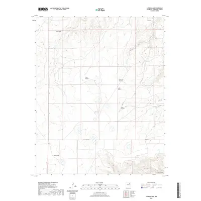
2020 Map of Llonidas Lake
USGS Topo · Published 2020About this map
Mathews Cem and Maes Cem represent the quiet traces of human settlement in this high-altitude landscape of San Miguel County. The terrain is defined by a series of deep drainage features, including Cañon Cibolo to the north and Cañon Carriso in the southwest. These canyons, such as Cañon Pinabete and Cañon Agua Chiquito, create a complex network of ridges and depressions that govern the movement of water and travelers alike. Local transit is largely limited to unpaved routes like Co RD C 53 A, which winds through the central area near Cañon Encinoso. The geography recorded here by the U.S. Geological Survey shows a sparse, high-desert environment where family burial grounds like those of the Maes and Mathews families remain as the primary landmarks in an otherwise open range.
Find a feature on this map
11 named features on this map. Tap any name to fly to it.
Don’t see what you’re looking for? This feature index may not catch every label — zoom into the map to look around manually.
Map Details
Editions of this 2020 Llonidas Lake Map
This is the sole edition of this map. No revisions or reprints were ever made.
Other maps of this area

1892 · Watrous
USGS Topo · 1:125,000

1894 · Watrous
USGS Topo · 1:125,000

1954 · Santa Fe
USGS Topo · 1:250,000

1958 · Santa Fe
USGS Topo · 1:250,000

1964 · Frutosa Lake
USGS Topo · 1:24,000

1964 · Canon Ancho
USGS Topo · 1:24,000
1966 · Cherry Valley Lake
USGS Topo · 1:24,000

1971 · Laguna Huerfana
USGS Topo · 1:24,000
1971 · Canon Pedroso
USGS Topo · 1:24,000

1971 · Trujillo
USGS Topo · 1:24,000