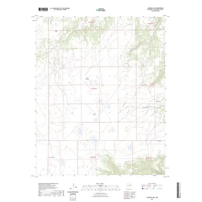
2023 Map of Llonidas Lake
USGS Topo · Published 2023About this map
Mathews Cem and Maes Cem serve as quiet markers of the ranching history and family lineage in this pocket of San Miguel County. The landscape is defined by a series of deep drainage cuts, including Cañon Pinabete and Cañon Cibolo, which shape the movement of local travel across the high plains. These canyons dictate the path of rural infrastructure like Co RD C 53 A, showing how topographic constraints continue to influence the modern road network.
Find a feature on this map
17 named features on this map. Tap any name to fly to it.
Don’t see what you’re looking for? This feature index may not catch every label — zoom into the map to look around manually.
Map Details
Editions of this 2023 Llonidas Lake Map
This is the sole edition of this map. No revisions or reprints were ever made.
Other maps of this area

1892 · Watrous
USGS Topo · 1:125,000

1894 · Watrous
USGS Topo · 1:125,000

1954 · Santa Fe
USGS Topo · 1:250,000

1958 · Santa Fe
USGS Topo · 1:250,000

1964 · Frutosa Lake
USGS Topo · 1:24,000

1964 · Canon Ancho
USGS Topo · 1:24,000
1966 · Cherry Valley Lake
USGS Topo · 1:24,000

1971 · Laguna Huerfana
USGS Topo · 1:24,000
1971 · Canon Pedroso
USGS Topo · 1:24,000

1971 · Trujillo
USGS Topo · 1:24,000