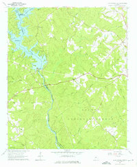
1964 Map of Lloyd Shoals Dam
USGS Topo · Published 1976About this map
Lloyd Shoals Dam controls the convergence of the South River, Alcovy River, and Tussahaw Creek, forming the expansive Jackson Lake at a normal pool elevation of 527 feet. This mid-1960s landscape in Jasper County is characterized by the transition from the reservoir’s indented shoreline to the timbered tracts of the Oconee National Forest. The map provides significant genealogical value through its density of rural community centers, including Leverette Neck and Bethel. Numerous country churches serve as landmarks across the rolling terrain, such as Mt Zion Ch, Bethlehem Ch, and Friendship Ch. South of the dam, the Ocmulgee River winds through the forest, passing Forty Acre Island and receiving several tributaries like Kinnard Creek and Wise Creek, illustrating a well-watered region where small family cemeteries and gaging stations are the primary markers of human activity.
Find a feature on this map
41 named features on this map. Tap any name to fly to it.
Don’t see what you’re looking for? This feature index may not catch every label — zoom into the map to look around manually.
Map Details
Editions of this 1964 Lloyd Shoals Dam Map
3 editions found
Other maps of this area

1951 · Forsyth
USGS Topo · 1:62,500

1953 · Athens
USGS Topo · 1:250,000

1958 · Athens
USGS Topo · 1:250,000

1959 · Athens
USGS Topo · 1:250,000

1963 · Athens
USGS Topo · 1:250,000

1964 · Lloyd Shoals Dam
USGS Topo · 1:24,000
1964 · Jackson
USGS Topo · 1:24,000

1964 · Stewart
USGS Topo · 1:24,000

1964 · Hillsboro
USGS Topo · 1:24,000

1964 · Worthville
USGS Topo · 1:24,000