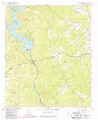
1964 Map of Lloyd Shoals Dam
USGS Topo · Published 1986About this map
Lloyd Shoals Dam anchors this mid-century landscape where the South River and Alcovy River converge to form Lake Jackson. The map records a transition from the water-dominated geography of the reservoir to the managed timberlands of the Oconee National Forest. This interface created a distinct settlement pattern, with rural communities like Leverette Neck and Bethel situated along the high ground between creek drainages such as Tussahaw Creek and Hardys Creek.
Find a feature on this map
37 named features on this map. Tap any name to fly to it.
Don’t see what you’re looking for? This feature index may not catch every label — zoom into the map to look around manually.
Map Details
Editions of this 1964 Lloyd Shoals Dam Map
3 editions found
Other maps of this area

1951 · Forsyth
USGS Topo · 1:62,500

1953 · Athens
USGS Topo · 1:250,000

1958 · Athens
USGS Topo · 1:250,000

1959 · Athens
USGS Topo · 1:250,000

1963 · Athens
USGS Topo · 1:250,000

1964 · Lloyd Shoals Dam
USGS Topo · 1:24,000
1964 · Jackson
USGS Topo · 1:24,000

1964 · Stewart
USGS Topo · 1:24,000

1964 · Hillsboro
USGS Topo · 1:24,000

1964 · Worthville
USGS Topo · 1:24,000