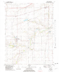
1981 Map of Loami
USGS Topo · Published 1982About this map
The village of Loami serves as the focal point of this Sangamon County landscape, situated at the intersection of local roads and the winding Lick Creek corridor. The area's mid-century transportation infrastructure is highly visible, with the Illinois Central Gulf Railroad cutting across the central township through Knapp, while the Norfolk and Western and Chicago and North Western lines serve the northern and eastern reaches.
Find a feature on this map
30 named features on this map. Tap any name to fly to it.
Don’t see what you’re looking for? This feature index may not catch every label — zoom into the map to look around manually.
Map Details
Editions of this 1981 Loami Map
This is the sole edition of this map. No revisions or reprints were ever made.
Other maps of this area

1907 · Springfield
USGS Topo · 1:62,500

1909 · Tallula
USGS Topo · 1:62,500

1922 · Divernon
USGS Topo · 1:62,500

1924 · Divernon
USGS Topo · 1:62,500

1924 · Waverly
USGS Topo · 1:62,500

1926 · Waverly
USGS Topo · 1:62,500

1930 · Springfield
USGS Topo · 1:62,500

1940 · Tallula
USGS Topo · 1:62,500

1940 · Springfield
USGS Topo · 1:62,500

1950 · Springfield West
USGS Topo · 1:24,000