
1967 Map of Lobdell
USGS Topo · Published 1968About this map
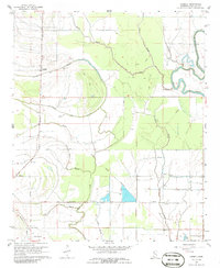
The Old Indian Treaty Boundary slices diagonally across this Bolivar County landscape, marking an enduring historical line amidst the Delta's agricultural grid. In the late 1960s, the community of Lobdell sits along the Illinois Central railroad, surrounded by a complex network of waterways including Stokes Bayou, Ann Bayou, and Christmas Lake. The map reveals a deeply rooted rural society defined by small churches and family burial grounds, such as Rice Chapel, Macedonia Ch, and the Polk-Royal Cem. To the east, the meandering Bogue Phalia creates a jagged natural border, contrasting with the straight irrigation flumes and pipelines that support the local plantations. Farther south, the settlement of Longshot and the Egypt Ridge Cem anchor the lower half of the quadrangle, where Stillwater Bayou and Clear Bayou drain the low-lying terrain.
Find a feature on this map
27 named features on this map. Tap any name to fly to it.
Don’t see what you’re looking for? This feature index may not catch every label — zoom into the map to look around manually.
Map Details
Editions of this 1967 Lobdell Map
2 editions found
Other maps of this area

1933 · Lamont
USGS Topo · 1:62,500

1939 · Pace
USGS Topo · 1:62,500

1939 · Big Island
USGS Topo · 1:62,500

1939 · Lamont
USGS Topo · 1:62,500

1939 · Choctaw
USGS Topo · 1:62,500

1953 · Greenwood
USGS Topo · 1:250,000

1956 · Greenwood
USGS Topo · 1:250,000

1967 · Stringtown
USGS Topo · 1:24,000
1967 · Skene
USGS Topo · 1:24,000
1967 · Shaw
USGS Topo · 1:24,000