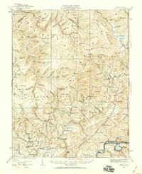
1935 Map of Lobelia
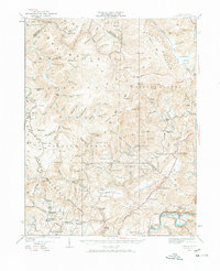
USGS Topo · Published 1959About this map
Lobelia and several rural settlements are documented here during a period of extensive culture revision in the mid-1930s. The landscape is defined by its educational and spiritual centers, featuring numerous community landmarks like Rockcamp School, Beulah Church, and Mt Zion Church. The eastern edge is anchored by the Chesapeake and Ohio railroad corridor near Renicks Valley, while the Seneca Trail cuts through the southern reaches of Monongahela National Forest.
Find a feature on this map
151 named features on this map. Tap any name to fly to it.
Don’t see what you’re looking for? This feature index may not catch every label — zoom into the map to look around manually.
Map Details
Editions of this 1935 Lobelia Map
2 editions found
Other maps of this area

1887 · Hinton
USGS Topo · 1:125,000

1887 · Lewisburg
USGS Topo · 1:125,000

1889 · Nicholas
USGS Topo · 1:125,000

1891 · Lewisburg
USGS Topo · 1:125,000

1891 · Nicholas
USGS Topo · 1:125,000

1891 · Huntersville
USGS Topo · 1:125,000

1892 · Hinton
USGS Topo · 1:125,000

1894 · Huntersville
USGS Topo · 1:125,000

1901 · Nicholas
USGS Topo · 1:125,000

1915 · Webster Springs
USGS Topo · 1:48,000