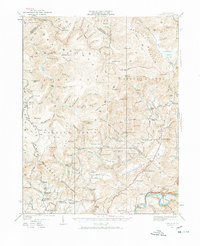
1935 Map of Lobelia
USGS Topo · Published 1966About this map
Cherry Mountain and the high ridges of Kennison Mountain dominate this landscape during a period of transition in the West Virginia highlands. The 1935 culture revision documents a region defined by scattered mountain communities and a significant investment in educational and spiritual life, evidenced by a high density of rural institutions such as Mt Lebanon School, Beulah Church, and Rockcamp Church. The Seneca Trail winds through the eastern valleys, providing a vital north-south artery near Lobelia and Loveridge.
Find a feature on this map
124 named features on this map. Tap any name to fly to it.
Don’t see what you’re looking for? This feature index may not catch every label — zoom into the map to look around manually.
Map Details
Editions of this 1935 Lobelia Map
2 editions found
Other maps of this area

1887 · Hinton
USGS Topo · 1:125,000

1887 · Lewisburg
USGS Topo · 1:125,000

1889 · Nicholas
USGS Topo · 1:125,000

1891 · Lewisburg
USGS Topo · 1:125,000

1891 · Nicholas
USGS Topo · 1:125,000

1891 · Huntersville
USGS Topo · 1:125,000

1892 · Hinton
USGS Topo · 1:125,000

1894 · Huntersville
USGS Topo · 1:125,000

1901 · Nicholas
USGS Topo · 1:125,000

1915 · Webster Springs
USGS Topo · 1:48,000