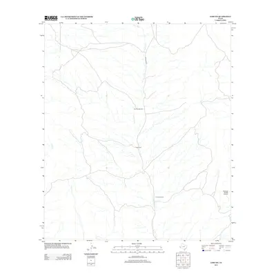
2012 Map of Lobo SW
USGS Topo · Published 2012About this map
Taylor Ranch serves as a primary reference point in this arid stretch of Culberson County, where human presence is defined by essential water infrastructure. The landscape is marked by the Mica Mine Windmill and Formwalt Windmill, which reflect the ranching and mining heritage of this high desert region. Drainage systems like Squaw Cr and the Green River carve through the terrain, leading toward distinctive landforms such as Hammer Handle Canyon. The primary corridor through this territory is the unpaved Green River Rd, which connects these isolated outposts. Natural water sources like Wilson Spring provide rare points of relief in a geography dominated by ephemeral streams and rugged canyon systems.
Find a feature on this map
8 named features on this map. Tap any name to fly to it.
Don’t see what you’re looking for? This feature index may not catch every label — zoom into the map to look around manually.
Map Details
Editions of this 2012 Lobo SW Map
This is the sole edition of this map. No revisions or reprints were ever made.
Other maps of this area

1892 · Chispa
USGS Topo · 1:125,000

1895 · Chispa
USGS Topo · 1:125,000

1897 · Eagle Mountain
USGS Topo · 1:125,000

1897 · Chispa
USGS Topo · 1:125,000

1916 · Eagle Mountain
USGS Topo · 1:125,000

1959 · Marfa
USGS Topo · 1:250,000

1965 · Marfa
USGS Topo · 1:250,000
1972 · Van Horn Wells
USGS Topo · 1:24,000
1972 · Lobo
USGS Topo · 1:24,000
1972 · Lobo SW
USGS Topo · 1:24,000