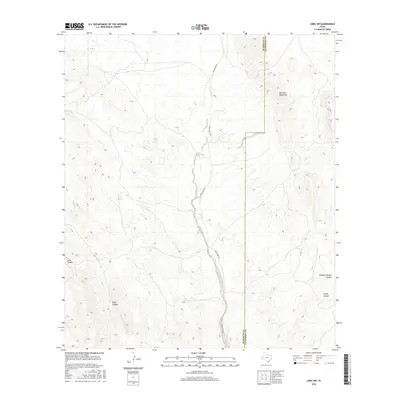
2016 Map of Lobo SW
USGS Topo · Published 2016About this map
Van Horn Mountains dominate the eastern reaches of this Trans-Pecos landscape, where high desert elevations descend into a series of drainage systems. The Green River serves as the primary hydrological feature, carving a north-south path through the center of the quadrangle and followed closely by Green River Rd. This corridor represents a vital passage through the arid terrain, linking disparate water sources such as Wilson Spring and Squaw Cr. The topography is defined by deep incisions in the mountain flanks, including Echo Canyon and Eagle Canyon to the west, and the aptly named Hammer Handle Canyon and China Canyon to the east. This survey captures the remote character of the Hudspeth and Culberson County line, illustrating the sparse infrastructure and natural water dependencies characteristic of this high-altitude desert environment.
Find a feature on this map
10 named features on this map. Tap any name to fly to it.
Don’t see what you’re looking for? This feature index may not catch every label — zoom into the map to look around manually.
Map Details
Editions of this 2016 Lobo SW Map
This is the sole edition of this map. No revisions or reprints were ever made.
Other maps of this area

1892 · Chispa
USGS Topo · 1:125,000

1895 · Chispa
USGS Topo · 1:125,000

1897 · Eagle Mountain
USGS Topo · 1:125,000

1897 · Chispa
USGS Topo · 1:125,000

1916 · Eagle Mountain
USGS Topo · 1:125,000

1959 · Marfa
USGS Topo · 1:250,000

1965 · Marfa
USGS Topo · 1:250,000
1972 · Van Horn Wells
USGS Topo · 1:24,000
1972 · Lobo
USGS Topo · 1:24,000
1972 · Lobo SW
USGS Topo · 1:24,000