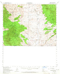
1958 Map of Lochiel
USGS Topo · Published 1965About this map
Duquesne and Washington Camp serve as the industrial anchors of this high-altitude mining district within the Coronado National Forest. This 1958 revision captures a landscape defined by complex mineral extraction, where dozens of named workings like the Worlds Fair Mine, Lead Queen Mine, and Trench Camp dot the terrain near American Peak. The map provides an intimate look at the copper and silver mining infrastructure that shaped the Patagonia Mountains during the mid-20th century.
Find a feature on this map
96 named features on this map. Tap any name to fly to it.
Don’t see what you’re looking for? This feature index may not catch every label — zoom into the map to look around manually.
Map Details
Editions of this 1958 Lochiel Map
2 editions found
Other maps of this area

1904 · Patagonia
USGS Topo · 1:125,000

1905 · Patagonia
USGS Topo · 1:125,000

1905 · Nogales
USGS Topo · 1:125,000

1914 · Hereford
USGS Topo · 1:125,000

1915 · Benson
USGS Topo · 1:125,000

1922 · Agus Caliente
USGS Topo · 1:62,500

1922 · Sunnyside
USGS Topo · 1:62,500

1932 · Lochiel
USGS Topo · 1:62,500

1932 · Elgin
USGS Topo · 1:62,500

1933 · Calabasas
USGS Topo · 1:62,500