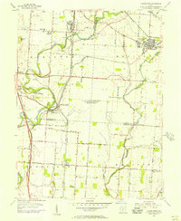
1955 Map of Lockbourne
USGS Topo · Published 1956About this map
The U S Military Reservation (Lockbourne Air Force Base) dominates the central landscape of this mid-1950s survey, representing a significant Strategic Air Command presence south of Columbus. Surrounding this military installation, the map captures a rural Ohio transition where traditional agriculture meets early suburban development. The transportation network is defined by the winding Scioto River to the west and the massive path of the Ohio Canal (Abandoned), which runs parallel to the Norfolk and Western and Chesapeake and Ohio railroads. Small community hubs like Lockbourne, Groveport, and Obetz are documented with fine detail, showing the placement of neighborhood landmarks like the Township High Sch and St Vincent Ch. The intersection of rail lines and old water routes reveals the deep industrial and transit history of Franklin and Pickaway Counties before the era of major interstate expansion.
Find a feature on this map
72 named features on this map. Tap any name to fly to it.
Don’t see what you’re looking for? This feature index may not catch every label — zoom into the map to look around manually.
Map Details
Editions of this 1955 Lockbourne Map
This is the sole edition of this map. No revisions or reprints were ever made.
Other maps of this area

1911 · Era
USGS Topo · 1:62,500

1913 · Era
USGS Topo · 1:62,500

1914 · Circleville
USGS Topo · 1:62,500

1923 · West Columbus
USGS Topo · 1:62,500

1925 · East Columbus
USGS Topo · 1:62,500

1925 · West Columbus
USGS Topo · 1:62,500

1943 · Era
USGS Topo · 1:62,500

1943 · Circleville
USGS Topo · 1:62,500

1943 · East Columbus
USGS Topo · 1:62,500

1947 · Columbus
USGS Topo · 1:250,000