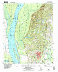
1997 Map of Locke
USGS Topo · Published 2000About this map
Chickasaw Bluff No 2 rises sharply from the eastern bank of the Mississippi River, creating a dramatic elevation change that separates the bottomland sloughs of Meeman-Shelby Forest State Park from the upland settlements of Shelby County. This late 20th-century view documents the complex hydrologic landscape where the Loosahatchie River and Big Creek Drainage Canal converge. Along the bluffs, rural communities like Locke and Benjestown are anchored by long-standing social institutions, including Jeter Sch, Mt Vernon Ch, and St Pauls Cem. The riverfront itself remains a network of active and former channels, marked by river landings such as Brandywine Landing and Cigarette Landing. The map captures the persistence of small upland hamlets like Giles Town and Ramsey even as the western edge of the quadrangle remains dominated by the shifting chutes and dikes of the river's floodplains.
Find a feature on this map
78 named features on this map. Tap any name to fly to it.
Don’t see what you’re looking for? This feature index may not catch every label — zoom into the map to look around manually.
Map Details
Editions of this 1997 Locke Map
This is the sole edition of this map. No revisions or reprints were ever made.
Other maps of this area

1916 · Memphis
USGS Topo · 1:62,500

1925 · Memphis
USGS Topo · 1:48,000

1927 · Memphis
USGS Topo · 1:62,500

1931 · Jericho
USGS Topo · 1:62,500

1939 · Jericho
USGS Topo · 1:62,500

1939 · Memphis
USGS Topo · 1:62,500

1942 · Millington
USGS Topo · 1:62,500

1952 · Jericho
USGS Topo · 1:62,500

1953 · Memphis
USGS Topo · 1:250,000

1955 · Memphis
USGS Topo · 1:62,500