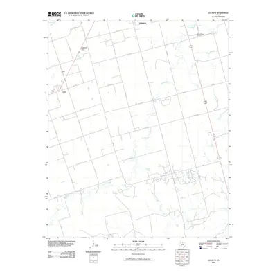
2010 Map of Lockett
USGS Topo · Published 2010About this map
Lockett and the outskirts of Vernon anchor this Wilbarger County landscape, where the agricultural grid of the Texas Rolling Plains meets the winding drainages of Paradise Creek and Turkey Creek. The map documents a rural infrastructure defined by an extensive network of farm-to-market roads and county routes that connect isolated farmsteads to local hubs. Near the northern edge, the Pease River cuts through the terrain, while landmarks such as the Santa Rosa Roundup Rodeo Grounds and Wilbarger Memorial Park indicate the area's role as a regional center for community gathering and heritage. Aviation and transportation history is marked by the presence of Lockett Airport, serving the small community and surrounding wheat and cotton acreage. The dense web of numbered county roads, from Co Rd 128 W to Co Rd 142 W, illustrates the systematic division of land that has supported North Texas ranching and farming for generations.
Find a feature on this map
32 named features on this map. Tap any name to fly to it.
Don’t see what you’re looking for? This feature index may not catch every label — zoom into the map to look around manually.
Map Details
Editions of this 2010 Lockett Map
This is the sole edition of this map. No revisions or reprints were ever made.
Other maps of this area

1954 · Wichita Falls
USGS Topo · 1:250,000

1955 · Lawton
USGS Topo · 1:250,000

1958 · Wichita Falls
USGS Topo · 1:250,000

1958 · Davidson
USGS Topo · 1:62,500

1958 · Vernon
USGS Topo · 1:62,500

1966 · Santa Rosa Lake
USGS Topo · 1:24,000

1966 · Grayback
USGS Topo · 1:24,000
1966 · Santa Rosa Lake NW
USGS Topo · 1:24,000
1983 · Boggy Creek
USGS Topo · 1:24,000

1983 · Tolbert
USGS Topo · 1:24,000