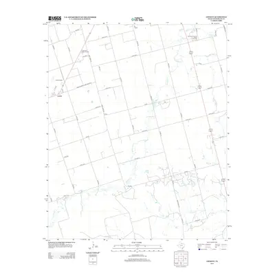
2012 Map of Lockett
USGS Topo · Published 2012About this map
Lockett anchors this portion of Wilbarger County, where the agricultural landscape is organized by an extensive grid of county roads and farm-to-market routes. The terrain is defined by the winding paths of Paradise Cr and Turkey Cr, which break the geometric precision of the surrounding fields. Local history and community identity are centered around landmarks like the Santa Rosa Roundup Rodeo Grounds and Wilbarger Memorial Park, reflecting the region's ranching traditions and civic development. The presence of the Lockett Airport and major transportation corridors like Farm-To-Market Road 433 W and the shared alignment of Highway 183 283 illustrate the infrastructure supporting this rural Texas hub in the early twenty-first century.
Find a feature on this map
41 named features on this map. Tap any name to fly to it.
Don’t see what you’re looking for? This feature index may not catch every label — zoom into the map to look around manually.
Map Details
Editions of this 2012 Lockett Map
This is the sole edition of this map. No revisions or reprints were ever made.
Other maps of this area

1954 · Wichita Falls
USGS Topo · 1:250,000

1955 · Lawton
USGS Topo · 1:250,000

1958 · Wichita Falls
USGS Topo · 1:250,000

1958 · Davidson
USGS Topo · 1:62,500

1958 · Vernon
USGS Topo · 1:62,500

1966 · Santa Rosa Lake
USGS Topo · 1:24,000

1966 · Grayback
USGS Topo · 1:24,000
1966 · Santa Rosa Lake NW
USGS Topo · 1:24,000
1983 · Boggy Creek
USGS Topo · 1:24,000

1983 · Tolbert
USGS Topo · 1:24,000