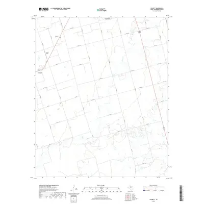
2019 Map of Lockett
USGS Topo · Published 2019About this map
Lockett serves as a central hub for the agricultural landscape of Wilbarger County, defined by a rigid grid of country roads and the meandering path of Paradise Cr. The area is characterized by large rural tracts and essential community infrastructure, including the Wilbarger Memorial Park and the Lockett Airport. To the northeast, the outskirts of Vernon begin to appear, while the southern portion of the quadrangle is drained by Turkey Cr. The network of Farm to Market roads, such as FM 2074 and FM 433 W, illustrates the transport-heavy nature of this farming region. Small pockets of wetlands and scattered ponds across the terrain suggest the careful management of water resources in a region where local creeks provide the primary natural drainage.
Find a feature on this map
36 named features on this map. Tap any name to fly to it.
Don’t see what you’re looking for? This feature index may not catch every label — zoom into the map to look around manually.
Map Details
Editions of this 2019 Lockett Map
This is the sole edition of this map. No revisions or reprints were ever made.
Other maps of this area

1954 · Wichita Falls
USGS Topo · 1:250,000

1955 · Lawton
USGS Topo · 1:250,000

1958 · Wichita Falls
USGS Topo · 1:250,000

1958 · Davidson
USGS Topo · 1:62,500

1958 · Vernon
USGS Topo · 1:62,500

1966 · Santa Rosa Lake
USGS Topo · 1:24,000

1966 · Grayback
USGS Topo · 1:24,000
1966 · Santa Rosa Lake NW
USGS Topo · 1:24,000
1983 · Boggy Creek
USGS Topo · 1:24,000

1983 · Tolbert
USGS Topo · 1:24,000